படிமம்:Sahel Map-Africa rough.png

இந்த முன்னோட்டத்தின் அளவு: 800 × 370 படப்புள்ளிகள் . மற்ற பிரிதிறன்கள்: 320 × 148 படப்புள்ளிகள் | 640 × 296 படப்புள்ளிகள் | 1,024 × 474 படப்புள்ளிகள் | 2,000 × 925 படப்புள்ளிகள் .
மூலக்கோப்பு (2,000 × 925 படவணுக்கள், கோப்பின் அளவு: 291 KB, MIME வகை: image/png)
| இது விக்கிமீடியா பொதுக்கோப்பகத்தில் இருக்கும் ஒரு கோப்பாகும். இக்கோப்பைக் குறித்து அங்கே காணப்படும் படிம விளக்கப் பக்கத்தை இங்கே கீழே காணலாம்.
|
| விளக்கம் |
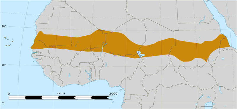
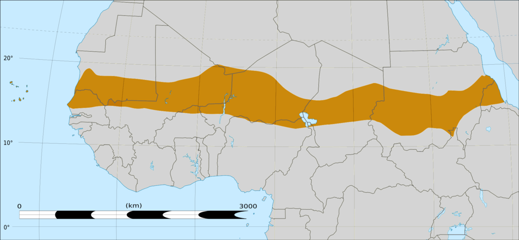
English: Map of Africa, with the Sahel highlighted in orange.
This is roughly the African land area between the lines of 200mm (north) and 600mm (south) mean 20th century annual rainfall. This is limited to land areas directly to the south of the Sahara desert and including the islands of Cape Verde, but not including other areas in Africa with the same rainfall statistics. This is one, but not the only, definition of the Sahel region. |
|||
| நாள் | 20 பெப்பிரவரி 2009 03:54 (UTC) | |||
| மூலம் |
Felix Koenig: "created/photographed by myself (based on the existing blank map of Africa)"
|
|||
| ஆசிரியர் | ||||
| ஒத்தக்கோப்பு |
|


| இது ஒரு திருத்தப்பட்ட படிமமாகும், அதாவது இதன் மூல வடிவத்திலிருந்து கணினி மூலம் இதில் மாற்றங்கள் செய்யப்பட்டுள்ளது. திருத்தங்கள்: Reproduced Sahel boundary from Map sahel.jpg on png map, cropped. மூலக்கோப்பை இங்கு காணலாம்: BlankMap-Africa2.png. திருத்தங்களைச் செய்தவர் T L Miles.
|
அனுமதி
இந்த ஆக்கத்தின் காப்புரிமையாளரான நான் இதனைப் பின்வரும் உரிமத்தின் கீழ் வெளியிடுகின்றேன்:

|
GNU Free Documentation License விதிமுறைகளின் கீழ் இந்த ஆவணத்தை நகலெடுக்க, விநியோகிக்க மற்றும்/அல்லது மாற்றுவதற்கு அனுமதி வழங்கப்பட்டுள்ளது, Free Software Foundation;ஆல் வெளியிடப்பட்ட பதிப்பு 1.2 அல்லது அதற்குப் பிந்தைய பதிப்பு, மாற்றமில்லாத பிரிவுகள், முன் அட்டை உரைகள் மற்றும் பின் அட்டை உரைகள் இல்லாமல் வெளியிடப்பட்டது. GNU Free Documentation License என்ற தலைப்பில் உரிமத்தின் நகல் சேர்க்கப்பட்டுள்ளது. |
This file is licensed under the Creative Commons Attribution-Share Alike 4.0 International, 3.0 Unported, 2.5 Generic, 2.0 Generic and 1.0 Generic license.
- நீங்கள் சுதந்திரமாக:
- பகிர்ந்து கொள்ள – வேலையை நகலெடுக்க, விநியோகிக்க மற்றும் அனுப்ப
- மீண்டும் கலக்க – வேலைக்கு பழகிக்கொள்ள.
- கீழ்க்காணும் விதிகளுக்கு ஏற்ப,
- பண்புக்கூறுகள் – நீங்கள் பொருத்தமான உரிமையை வழங்க வேண்டும், உரிமத்திற்கான இணைப்பை வழங்க வேண்டும் மற்றும் மாற்றங்கள் செய்யப்பட்டிருந்தால் குறிப்பிட வேண்டும். நீங்கள் ஏற்புடைய எந்த முறையிலும் அவ்வாறு செய்யலாம், ஆனால் எந்த வகையிலும் உரிமதாரர் உங்களை அல்லது உங்கள் பயன்பாட்டிற்கு ஒப்புதல் அளிக்கும் படி பரிந்துரைக்க கூடாது.
- அதே மாதிரி பகிர் – நீங்கள் ரீமிக்ஸ் செய்தாலோ, உருமாற்றம் செய்தாலோ அல்லது பொருளை உருவாக்கினாலோ, உங்கள் பங்களிப்புகளை அல்லது இணக்கமான உரிமம் கீழ் அசலாக விநியோகிக்க வேண்டும்.
நீர் உமக்கு விருப்பமான உரிமத்தை தேர்ந்தெடுக்கலாம்.
|
|
GNU Free Documentation License விதிமுறைகளின் கீழ் இந்த ஆவணத்தை நகலெடுக்க, விநியோகிக்க மற்றும்/அல்லது மாற்றுவதற்கு அனுமதி வழங்கப்பட்டுள்ளது, Free Software Foundation;ஆல் வெளியிடப்பட்ட பதிப்பு 1.2 அல்லது அதற்குப் பிந்தைய பதிப்பு, மாற்றமில்லாத பிரிவுகள், முன் அட்டை உரைகள் மற்றும் பின் அட்டை உரைகள் இல்லாமல் வெளியிடப்பட்டது. GNU Free Documentation License என்ற தலைப்பில் உரிமத்தின் நகல் சேர்க்கப்பட்டுள்ளது. |
Original upload log
This image is a derivative work of the following images:
- File:Map_sahel.jpg licensed with GFDL
- 2005-05-30T17:36:46Z King 800x800 (89588 Bytes) one moment please
- File:BlankMap-Africa2.png licensed with Cc-by-sa-3.0,2.5,2.0,1.0, GFDL
- 2008-03-08T18:02:20Z Sadalmelik 1754x1546 (51013 Bytes) {{Information |Description=Blank map of Africa |Source=self-made |Date=2008-03-08 |Author= [[User:Sadalmelik|Sadalmelik]] |Permission= |other_versions= }} [[Category:Blank maps of Africa]]
Uploaded with derivativeFX
கோப்பின் வரலாறு
குறித்த நேரத்தில் இருந்த படிமத்தைப் பார்க்க அந்நேரத்தின் மீது சொடுக்கவும்.
| நாள்/நேரம் | நகம் அளவு சிறுபடம் | அளவுகள் | பயனர் | கருத்து | |
|---|---|---|---|---|---|
| தற்போதைய | 16:15, 17 மார்ச்சு 2018 | | 2,000 × 925 (291 KB) | Maphobbyist | South Sudan border |
| 04:02, 20 பெப்பிரவரி 2009 |  | 1,384 × 658 (29 KB) | T L Miles | {{Information |Description=*Description: A map of Africa: the Sahel highlighted in orange. Note, this is ROUGHLY the African land area between the lines of 200mm (north) and 600mm (south) mean 20th century annual rainfall. This is limited to land areas d |
கோப்பு பயன்பாடு
கோப்பின் முழுமையான பயன்பாடு
கீழ்கண்ட மற்ற விக்கிகள் இந்த கோப்பை பயன்படுத்துகின்றன:
- af.wiki.x.io-திட்டத்தில் இதன் பயன்பாடு
- als.wiki.x.io-திட்டத்தில் இதன் பயன்பாடு
- ar.wiki.x.io-திட்டத்தில் இதன் பயன்பாடு
- az.wiki.x.io-திட்டத்தில் இதன் பயன்பாடு
- bcl.wiki.x.io-திட்டத்தில் இதன் பயன்பாடு
- be.wiki.x.io-திட்டத்தில் இதன் பயன்பாடு
- bg.wiki.x.io-திட்டத்தில் இதன் பயன்பாடு
- bn.wiki.x.io-திட்டத்தில் இதன் பயன்பாடு
- br.wiki.x.io-திட்டத்தில் இதன் பயன்பாடு
- ca.wiki.x.io-திட்டத்தில் இதன் பயன்பாடு
- ce.wiki.x.io-திட்டத்தில் இதன் பயன்பாடு
- cy.wiki.x.io-திட்டத்தில் இதன் பயன்பாடு
- da.wiki.x.io-திட்டத்தில் இதன் பயன்பாடு
- en.wiki.x.io-திட்டத்தில் இதன் பயன்பாடு
- eo.wiki.x.io-திட்டத்தில் இதன் பயன்பாடு
- eu.wiki.x.io-திட்டத்தில் இதன் பயன்பாடு
- fa.wiki.x.io-திட்டத்தில் இதன் பயன்பாடு
- fi.wiktionary.org-திட்டத்தில் இதன் பயன்பாடு
- fr.wiki.x.io-திட்டத்தில் இதன் பயன்பாடு
- fr.wikinews.org-திட்டத்தில் இதன் பயன்பாடு
- ha.wiki.x.io-திட்டத்தில் இதன் பயன்பாடு
- ig.wiki.x.io-திட்டத்தில் இதன் பயன்பாடு
- incubator.wikimedia.org-திட்டத்தில் இதன் பயன்பாடு
- it.wiki.x.io-திட்டத்தில் இதன் பயன்பாடு
- ja.wiki.x.io-திட்டத்தில் இதன் பயன்பாடு
- ka.wiki.x.io-திட்டத்தில் இதன் பயன்பாடு
- ko.wiki.x.io-திட்டத்தில் இதன் பயன்பாடு
சிறப்பு பக்கம்-மொத்த பயன்பாடு - இதன் மூலம் இந்த கோப்பின் மொத்த பயன்பாட்டை அறிய முடியும்