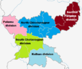
படிமம்:Jharkhand divisions map.png
Jharkhand_divisions_map.png (512 × 427 படவணுக்கள், கோப்பின் அளவு: 62 KB, MIME வகை: image/png)
கோப்பின் வரலாறு
குறித்த நேரத்தில் இருந்த படிமத்தைப் பார்க்க அந்நேரத்தின் மீது சொடுக்கவும்.
| நாள்/நேரம் | நகம் அளவு சிறுபடம் | அளவுகள் | பயனர் | கருத்து | |
|---|---|---|---|---|---|
| தற்போதைய | 11:32, 5 அக்டோபர் 2013 |  | 512 × 427 (62 KB) | Gokulchandola | {{Information |Description ={{en|1=Source File is India_Jharkhand_location_map.svg}} |Source =File:India_Jharkhand_location_map.svg |Author =User:Gokulchandola |Date =2013-10-05 |Permission = |other_versions = }} |
கோப்பு பயன்பாடு
பின்வரும் பக்க இணைப்புகள் இப் படிமத்துக்கு இணைக்கபட்டுள்ளது(ளன):
கோப்பின் முழுமையான பயன்பாடு
கீழ்கண்ட மற்ற விக்கிகள் இந்த கோப்பை பயன்படுத்துகின்றன:
- anp.wiki.x.io-திட்டத்தில் இதன் பயன்பாடு
- en.wiki.x.io-திட்டத்தில் இதன் பயன்பாடு
- Godda district
- Santhal Pargana division
- Dhanbad
- Sindri (Dhanbad)
- Rajrappa
- Giridih
- Hazaribagh
- Deoghar
- Pakur
- Sahebganj
- Dumka
- Jamtara
- Rajmahal
- Bokaro Steel City
- Deoghar district
- Pakur district
- Sahebganj district
- Jamtara district
- Dumka district
- Dhanwar, Giridih
- Godda
- Bhadani Nagar
- Amlabad
- Angarpathar
- Babua Kalan
- Baliari
- Balkundra
- Bandhgora
- Barhi, Hazaribagh
- Barkakana
- Barughutu
- Basaria
- Basukinath
- Bermo
- Bhagatdih
- Bhojudih
- Bhowrah
- Bhuli, India
- Chandaur
- Chandrapura
- Chas, Bokaro
- Chhatatanr
- Chhotaputki
- Chirkunda
- Dhaunsar
- Dugda
- Dumarkunda
- Egarkunr
- Gidi, Hazaribagh
சிறப்பு பக்கம்-மொத்த பயன்பாடு - இதன் மூலம் இந்த கோப்பின் மொத்த பயன்பாட்டை அறிய முடியும்

