படிமம்:Amarnamap.png

இந்த முன்னோட்டத்தின் அளவு: 772 × 599 படப்புள்ளிகள் . மற்ற பிரிதிறன்கள்: 309 × 240 படப்புள்ளிகள் | 619 × 480 படப்புள்ளிகள் | 782 × 607 படப்புள்ளிகள் .
மூலக்கோப்பு (782 × 607 படவணுக்கள், கோப்பின் அளவு: 743 KB, MIME வகை: image/png)
| இது விக்கிமீடியா பொதுக்கோப்பகத்தில் இருக்கும் ஒரு கோப்பாகும். இக்கோப்பைக் குறித்து அங்கே காணப்படும் படிம விளக்கப் பக்கத்தை இங்கே கீழே காணலாம்.
|
சுருக்கம்
| விளக்கம் |
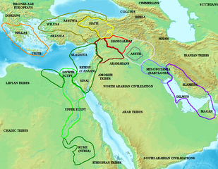
English: Map of the ancient Near East during the Amarna period, showing the great powers of the period: Egypt (green), Hatti (yellow), the Kassite kingdom of Babylon (purple), Assyria (grey), and Mittani (red). Lighter areas show direct control, darker areas represent spheres of influence. The extent of the Achaean/Mycenaean civilization is shown in orange.
On the map above: the territory between Medes and Iberia was called Ararat or Armenia, around the lake Van.
Русский: Карта Восточного Средиземноморья в Амарнский период (XIV век до н. э.). Территория Египта обведена зелёным, Митанни — красным, Хатти — жёлтым (покорённые ими территории обозначены более тёмными контурами того же цвета). |
||
| நாள் | |||
| மூலம் |
|
||
| ஆசிரியர் | Briangotts |

அனுமதி
இந்த ஆக்கத்தின் காப்புரிமையாளரான நான் இதனைப் பின்வரும் உரிமத்தின் கீழ் வெளியிடுகின்றேன்:

|
GNU Free Documentation License விதிமுறைகளின் கீழ் இந்த ஆவணத்தை நகலெடுக்க, விநியோகிக்க மற்றும்/அல்லது மாற்றுவதற்கு அனுமதி வழங்கப்பட்டுள்ளது, Free Software Foundation;ஆல் வெளியிடப்பட்ட பதிப்பு 1.2 அல்லது அதற்குப் பிந்தைய பதிப்பு, மாற்றமில்லாத பிரிவுகள், முன் அட்டை உரைகள் மற்றும் பின் அட்டை உரைகள் இல்லாமல் வெளியிடப்பட்டது. GNU Free Documentation License என்ற தலைப்பில் உரிமத்தின் நகல் சேர்க்கப்பட்டுள்ளது. |
| இந்த கோப்பு Creative Commons Attribution-Share Alike 3.0 Unported உரிமத்தின் கீழ் உள்ளது. | ||
| ||
| This licensing tag was added to this file as part of the GFDL licensing update. |
கோப்பின் வரலாறு
குறித்த நேரத்தில் இருந்த படிமத்தைப் பார்க்க அந்நேரத்தின் மீது சொடுக்கவும்.
| நாள்/நேரம் | நகம் அளவு சிறுபடம் | அளவுகள் | பயனர் | கருத்து | |
|---|---|---|---|---|---|
| தற்போதைய | 09:55, 3 திசம்பர் 2006 | | 782 × 607 (743 KB) | Electionworld | {{ew|en|Briangotts}} Map of the ancient Near East during the Amarna period, showing the great powers of the period: Egypt (green), Hatti (yellow), the Kassite kingdom of Babylon (purple), Assyria (grey), and Mittani (red). |
கோப்பு பயன்பாடு
பின்வரும் பக்க இணைப்புகள் இப் படிமத்துக்கு இணைக்கபட்டுள்ளது(ளன):
கோப்பின் முழுமையான பயன்பாடு
கீழ்கண்ட மற்ற விக்கிகள் இந்த கோப்பை பயன்படுத்துகின்றன:
- am.wiki.x.io-திட்டத்தில் இதன் பயன்பாடு
- ar.wiki.x.io-திட்டத்தில் இதன் பயன்பாடு
- ast.wiki.x.io-திட்டத்தில் இதன் பயன்பாடு
- az.wiki.x.io-திட்டத்தில் இதன் பயன்பாடு
- ba.wiki.x.io-திட்டத்தில் இதன் பயன்பாடு
- be.wiki.x.io-திட்டத்தில் இதன் பயன்பாடு
- bs.wiki.x.io-திட்டத்தில் இதன் பயன்பாடு
- ca.wiki.x.io-திட்டத்தில் இதன் பயன்பாடு
- diq.wiki.x.io-திட்டத்தில் இதன் பயன்பாடு
- el.wiki.x.io-திட்டத்தில் இதன் பயன்பாடு
- en.wiki.x.io-திட்டத்தில் இதன் பயன்பாடு
- es.wiki.x.io-திட்டத்தில் இதன் பயன்பாடு
- eu.wiki.x.io-திட்டத்தில் இதன் பயன்பாடு
- fi.wiki.x.io-திட்டத்தில் இதன் பயன்பாடு
- fr.wiki.x.io-திட்டத்தில் இதன் பயன்பாடு
- fy.wiki.x.io-திட்டத்தில் இதன் பயன்பாடு
- he.wiki.x.io-திட்டத்தில் இதன் பயன்பாடு
- hu.wiki.x.io-திட்டத்தில் இதன் பயன்பாடு
- hy.wiki.x.io-திட்டத்தில் இதன் பயன்பாடு
- hyw.wiki.x.io-திட்டத்தில் இதன் பயன்பாடு
- id.wiki.x.io-திட்டத்தில் இதன் பயன்பாடு
- ja.wiki.x.io-திட்டத்தில் இதன் பயன்பாடு
- jv.wiki.x.io-திட்டத்தில் இதன் பயன்பாடு
- mk.wiki.x.io-திட்டத்தில் இதன் பயன்பாடு
சிறப்பு பக்கம்-மொத்த பயன்பாடு - இதன் மூலம் இந்த கோப்பின் மொத்த பயன்பாட்டை அறிய முடியும்